Author: Metropolitan Corporation of Greater Winnipeg
Publ.: September 1970
Size: 895.2 K (PDF)
Fort Garry Detailed Area Plan
Map 1 - Location and Extent of Development
Map 2 - Urban Growth Pattern
Map 3 - Existing Land Use
Map 4 - Existing Zoning
Map 5 - Fort Garry Future Land Use
Map 6 - Local Planning Areas Index Map
Map 7 - Beaumont Future Land Use
Map 8 - Wildwood Future Land Use
Map 9 - McGillivray Future Land Use
Map 10 - University Future Land Use
Map 11 - Fort Richmond Future Land Use
Map 12 - Waverley Future Land Use
Map 13 - St. Norbert Future Land Use
Map 14 - Existing Services
Map 15 - Proposed Linear Riverbank Open Space System
7.31.2015
7.27.2015
Eyesores of Winnipeg
This blog post is gonna out all of the fugly or not well kept, or outlived its usefulness buildings and other public infrastructure in and around Winnipeg, Canada.
 |
| Osborne Village Inn |
- Osborne Village Inn
It's been there for years. It just needs to go, and be replaced with something bigger, nicer, taller. Make the new building a landmark for the whole of Osborne Village area.
Looks like other people feel the same way, as it was announced on 2015-08-11 that the Osborne Village Inn has been sold for redevelopment into a newer "botique" Hotel. Good news!
- Sherbrook Inn
Same thing with the Sherbrook Inn. The area around it is being gentrified. There are newer apartments, a Stella's cafe. The area doesn't need an SRO hotel with drunks wandering at night to make it unsafe.
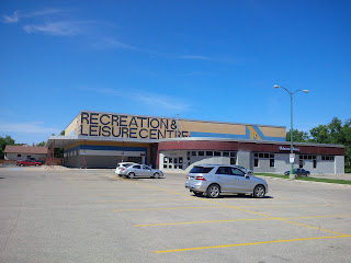
Just demo it and build something else. It doesn't have to be a Hotel or Inn. Make it a destination for the whole of the Sherbrook / West Broadway neighbourhood and those passing thru it. - Fort Rouge Leisure Centre building signage. It's the ugliest Rec. Centre signage in the metro area! It SHOUTS out "1975". It's outa date fonts, colours needed a serious update YESTERDAY! The integrated Osborne Library Branch is fine. I like it. But the Rec. Centre fascade needs to be changed to get with the times.
- Legion No. 84 - Smith St.

Veterans Legion No. 84 has been abandoned several years ago. It still stands empty to this day. Unused with no vision no possibility to be used for something else.
The BEST thing that could happen to this building would be for the owner or the City to have it demollished for something bigger & better.
This corner has a lot of potential, because of its proximity to the downtown Library, The Forks, and nearby public transit.
Back in the 1980s I used to pass this building when it was still occupied. It meant that I was getting close to the Library and it'd be soon time to get off the bus.


7.23.2015
7.22.2015
Tuxedo Detailed Area Plan
Tuxedo Detailed Area Plan [601.8 K]
Author: Metropolitan Corporation of Greater Winnipeg
Publ.: November 1970
7.21.2015
St. Vital Detailed Area Plan
Below are a few of the city planning documents written by the Metropolitan Corporation of Greater Winnipeg. These date back from the late 1960s into the early 1970s.
I have done my best to transcribe these documents as accurately as possible, though it is possible there may be errors.
As soon as I have more of the text I will place each plan onto a separate blog post and add in the maps (as PDFs) for your viewing pleasure.
I have done my best to transcribe these documents as accurately as possible, though it is possible there may be errors.
As soon as I have more of the text I will place each plan onto a separate blog post and add in the maps (as PDFs) for your viewing pleasure.
Detailed Area Plan - St. Vital [903.2 K]
Author: Metropolitan Corporation of Greater Winnipeg
Publ: December1968
St. Vital - Map 1
St. Vital - Map 2
St. Vital - Map 3 (Existing Land Use)
St. Vital - Map 4
St. Vital - Map 5
St. Vital - Map 6
St. Vital - Map 7
Author: Metropolitan Corporation of Greater Winnipeg
Publ: December1968
St. Vital - Map 1
St. Vital - Map 2
St. Vital - Map 3 (Existing Land Use)
St. Vital - Map 4
St. Vital - Map 5
St. Vital - Map 6
St. Vital - Map 7
Subscribe to:
Posts (Atom)